
Keyword
Marine Features (Australia) | Great Barrier Reef, QLD
117 record(s)
Type of resources
Topics
Keywords
Contact for the resource
Provided by
Formats
Update frequencies
Status
draft
-
Sentinel-3 OLCI reduced resolution (approximately 1000m-pixel size) daily reprojected Level 2P above-water spectral remote sensing reflectance produced by CSIRO under eReefs Phase 5 using the FUB-CSIRO Coastal Water Processor (detailed description at https://doi.org/10.1016/j.rse.2021.112848). This product was derived from Level 2 geophysical quantities, and placed onto a regular grid using nearest neighbor resampling. Standard Level 1 quality flags have been applied to pre-mask and quality control the data (see file_version_quality_control). Additional algorithm input and output out-of-range flags (in_out_OR_combined_flags) are provided to further quality control the data. These flags have not been applied to pre-mask the data.
-
Sentinel-3 OLCI reduced resolution (approximately 1000m-pixel size) daily Level 1B true-colour quicklooks produced by CSIRO under eReefs Phase 5 delivered in GeoTIFF format.
-
Sentinel-1 SAR medium resolution (approximately 20m-pixel size) reprojected and calibrated product produced by CSIRO under eReefs Phase 5 using the SNAP (Sentinel Application Platform) toolbox. This product was derived from Level 1 IW GRD (VV polarization), placed onto a regular grid using nearest neighbor resampling and radiometrically filtered using a three-pass combination of filters to reduce speckle.
-

DEPRECATED: This dataset has been superseeded by GBR4_H2p0_B2p0_Chyd_Dcrt(2010-12 to 2016-10) and then by GBR4_H2p0_B3p1_Cq3b_Dhnd (2010-04 to 2019-04). It will be decommissioned in April 2024. This is the eReefs GBR 4 km resolution Biogeochemistry (BGC) and Sediments model data version 926. It is based on the eReefs GBR 4 km Hydrodynamic SHOC model data for physical properties plus a sediment transport model for predicting the fate of suspended fine sediments and a biogeochemical model for water column and benthic production, water quality and nutrient cycling. It includes a spectrally resolved light model and is forced by a wave model to calculate resuspension rates of particulate matter
-
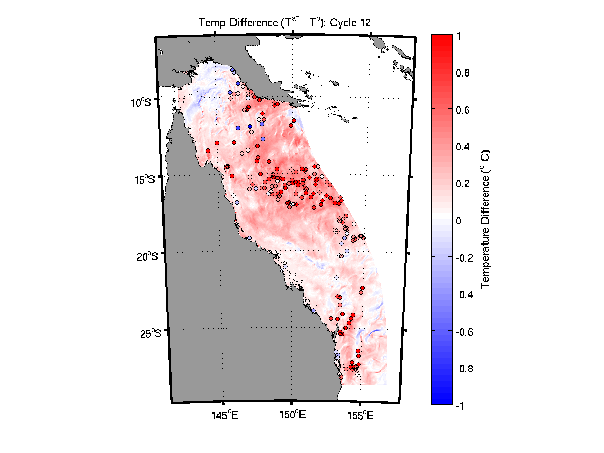
**This sample dataset was decomissioned in May 2022, and is no longer available via the NCI THREDDS server. Please contact the eReefs team if you need access to this data.** This is the eReefs GBR 4 km resolution Data Assimilating (DA) hydrodynamic SHOC model data. The Ensemble Optimal Interpolation (EnOI) system assimilaties a combination of temperature data from moorings (AIMS and GBROOS/IMOS), gliders (CSIRO and IMOS) and SST (GHRSST L3S from IMOS). This product is the first version of a reanalysis undertaken for the GBR4 grid. The DS system is run with a cycle length of 2 days, and assimilates temperature data that fall within a 6 hour window either side of the analysis time. The mean forecast error ranges from 0.4 degrees C in the "dry" season to 0.7 degrees C in the "wet" season
-

**This sample dataset was decomissioned in May 2022, and is no longer available via the NCI THREDDS server. Please contact the eReefs team if you need access to this data.** This is the eReefs GBR 4 km resolution complete hydrodynamic Sparse Hydrodynamic Ocean Code (SHOC) model data v1.85. It is comprised of ALL the tracers that are present in the SHOC model. The output format is non-CF compliant as it is a "standard" SHOC ALL file. It is based on the Arakawa-C grid with velocities on face centres that are oriented relative to the grid while all tracer values and surface elevation values are cell centred.
-
The pesticide diuron from urban and agricultural runoff is detected at concentrations above current water quality guidelines in the Great Barrier Reef (GBR) marine environment. We quantified the load of the pesticide diuron entering GBR waters using the GBR-Dynamic SedNet catchment model. After comparison of simulated distributions with observations at 11 monitoring sites we determined a half-life of diuron in GBR marine waters of 40 days. The 1 km resolution eReefs marine model (GBR1: version GBR1_H2p0_Cq3pe1_Dhnd) was nested inside the 4 km eReefs marine model (GBR4: version GBR4_H2p0) to achieve stable and reliable boundary forcing. Diuron only enters the marine model from the catchments. Diuron at the ocean boundaries is set to 0 and if diuron leaves the 1km model boundary it does not return. The simulation period is from January 2016 to July 2018. The GBR1 hydrodynamic model was forced by wind, atmospheric pressure gradients, surface heat fluxes and evaporation / precipitation fluxes, tides, and waves and calculates temperature, salinity, elevation and offshore currents, integrating on a 1.2 second barotropic time step. The hydrodynamic model calculates the mean volume flux through model cell faces over a 1-hour period (Herzfeld et al., 2016) that are used in a transport model to disperse diuron. The transport scheme was a flux-form semi-Lagrangian advection scheme that applies the fluxes in steps determined by the Lipschitz stability criterion, with a maximum of 1 hour time step. Each model cell contains their own value of diuron based on the hydrodynamics, and so diuron fluctuates hourly in each cell. The eReefs marine model represents freshwater input from 16 rivers located in the GBR. For rivers with freshwater input, GBR1 uses a river boundary condition where freshwater was discharged in a brackish surface plume. This boundary condition provides realistic plume dynamics and avoids excessive offshore transport caused by overestimating the density difference between freshwater plumes and seawater (Herzfeld, 2015, Baird et al., 2017). For the remaining minor rivers, diuron enters GBR coastal waters as loads as a surface flux (Figure 1B). Rivers containing high diuron loads that enter as surfaces fluxes were the Murray, Mossman, Proserpine and Burrum and Plane (very high risk). Some river catchments in GBR-SedNet do not contain diuron loads, (Normanby, Fitzroy, Calliope, Boyne, Styx, Shoalwater and Waterpark) as diuron was not one of the pesticides used or generally found within these catchment areas during frequent monitoring of all pesticides. Individual river plume dispersal was quantified using conservative tracers. A river tracer was specified as a unit concentration in each river flow (e.g., 1 kg m-3). Therefore, a model grid cell with 0.20 concentration of river water will be composed of 20 % river water, and 80 % water that comes either from another river/s or the ocean. Each river has a unique tracer that was individually advected and diffused using a conservation flux-form scheme based on hourly-averaged 3D velocity fields. Similarly, the diuron tracer has a time-varying river concentration in μg L-1 specified by the SedNet catchment model and was advected and diffused in a similar manner to the river tracers.
-
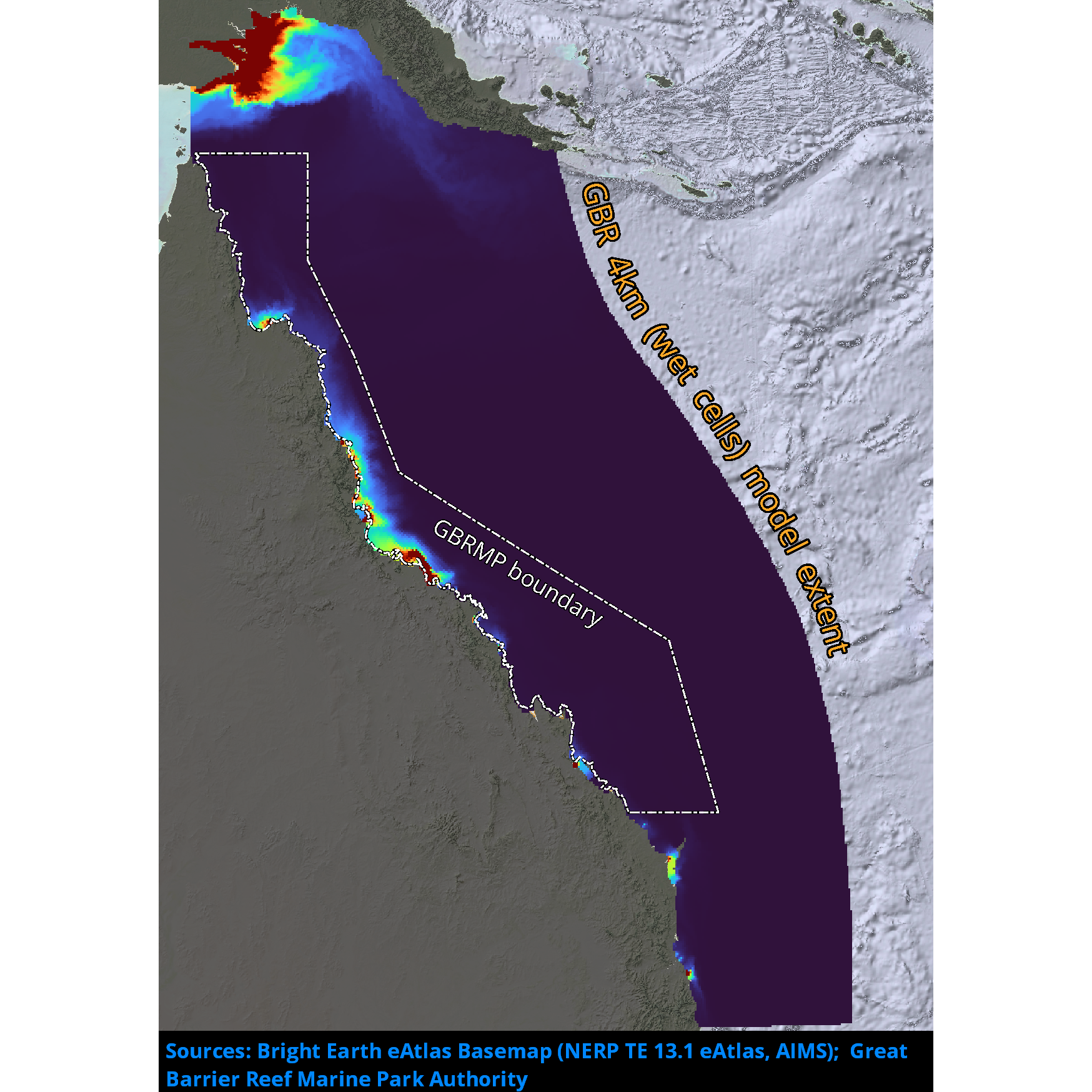
Passive river tracer results derived from version 2.0 of the 4km-resolution regional-scale hydrodynamic model of the Great Barrier Reef (GBR4). This model configuration and associated results dataset may be referred to as "GBR4_H2p0_Rivers" according to the eReefs simulation naming protocol. The model runs in near-real-time mode, updating daily.
-
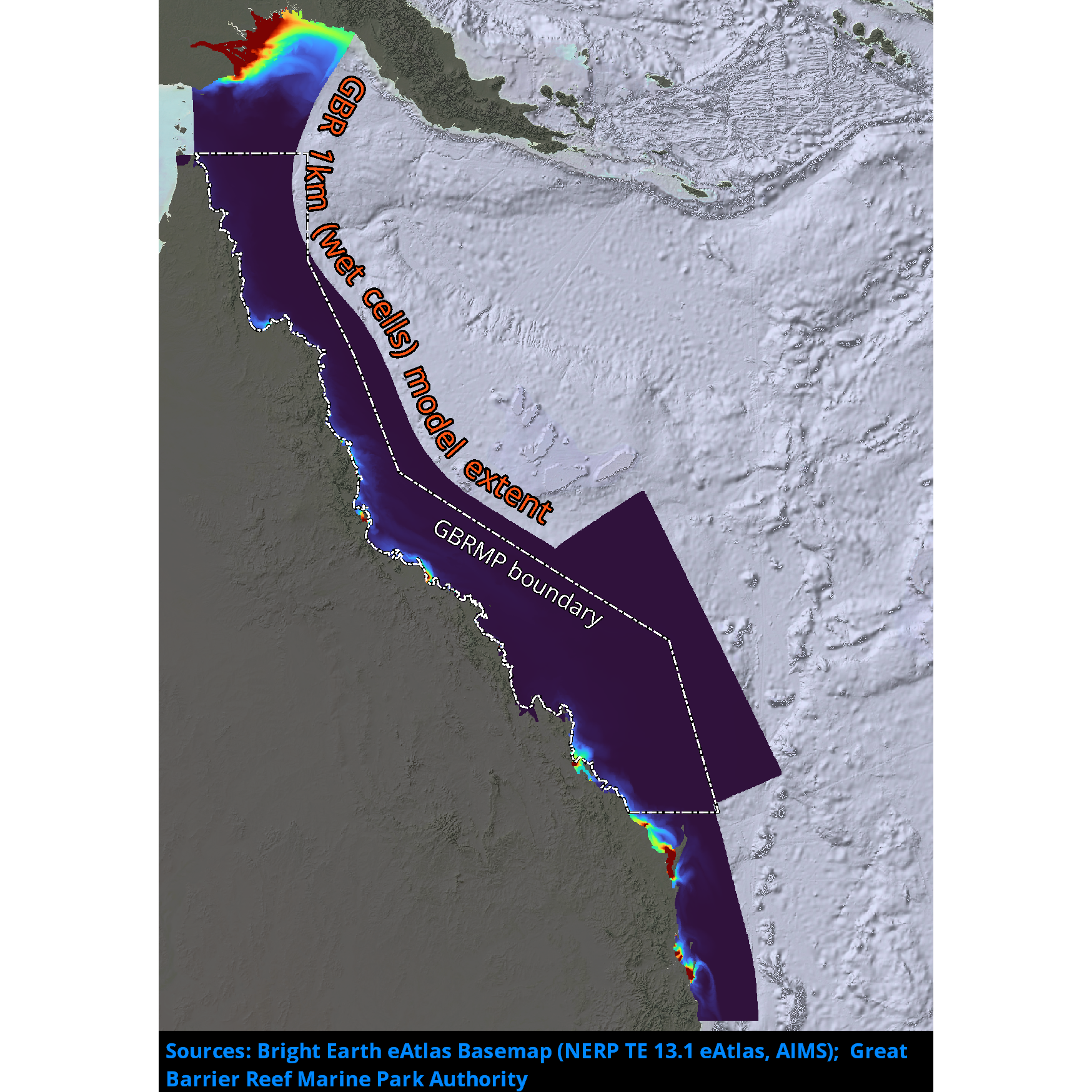
Passive river tracer results derived from version 2.0 of the 1km-resolution shelf-scale hydrodynamic model of the Great Barrier Reef (GBR1). This model configuration and associated results dataset may be referred to as "GBR1_H2p0_Rivers" according to the eReefs simulation naming protocol. The model runs in near-real-time mode, updating daily.
-
This record describes multibeam echosounder data collected on RV Investigator voyage IN2022_V07, HALO - Halimeda bioherm Origins, function and fate in the northern Great Barrier Reef." The voyage took place between August 15, 2022 and September 7, 2022 (AEST), departing from Brisbane and returning to Cairns. Piggyback project: Dinoflagellates & broader planktonic assemblage observation. The Kongsberg EM710 MKII multibeam echosounder was used to acquire seafloor bathymetry and backscatter information and watercolumn backscatter throughout the voyage. The system aquired data throughout transits within the Great Barrier Reef and was also run concurrently with the Kongsberg EM2040C system during site surveys. The EM710 MKII provides a 0.5° by 1° transmit and receive angular resolution respectively. The echosounder's nominal frequency range is from 40 to 100 kHz. Data are stored in *.all raw format for bathymetry and backscatter and *.wcd format for watercolumn backscatter at CSIRO. There are 694 files totalling 274 GB of raw data in this dataset. Sound velocity profiles were applied to this data during data acquisition. Bathymetry data contained in *.all format are corrected for motion and position. Predicted tides were calculated using AusTides 2022 and applied relative to MSL. Processed data has had outliers removed. Processed line data are available in *.gsf and ascii format, and processed bathymetry and backscatter grids in geotiff format. Additional information regarding this dataset, including further information on processing streams, is contained in the GSM data acquisition and processing report. Additional data products may be available on request.